

§ 58-85. Maximum height map regulations.
(a)
Purpose and intent. Notwithstanding the other applicable regulations within this article, this section is intended to establish special regulations and provisions governing building height which supplement the zoning height provisions outlined within the multifamily (R-4), office (O-1), office (O-2), commercial (C-1), commercial (C-2), commercial (C-3), commercial (C-3A), limited industrial (I-1), planned development (PD-1 and PD-2) and public, quasi-public (PQP) zoning districts by virtue of the adoption and establishment of a maximum height map. These regulations provide for and encourage compatible heights and densities in accordance with the comprehensive plan.
(b)
Application. These height overlay regulations shall be applied to the areas designated office, commercial or other nonresidential zoning districts as depicted on the maximum height map. Except within the central business district, these provisions are not intended for areas designated residential in the comprehensive plan. However, these provisions may be utilized to allow residential uses to be developed within a project, provided the underlying zoning designation is limited to one of the districts outlined in subsection (a).
(c)
Maximum height map adoption and implementation, Notwithstanding the heights as expressed in feet dimension as specified within the zoning districts' regulations, any property depicted on the maximum height map shall be restricted to the maximum number of building stories as set forth on that maximum height map. In other words, in the event of any conflict between the maximum height map and the heights allowed within the individual zoning districts' regulations, the maximum height map governs. Mezzanine or loft levels shall be considered an additional story. Parking garage levels shall be counted as stories for each level, except for any basement or open roof top level.
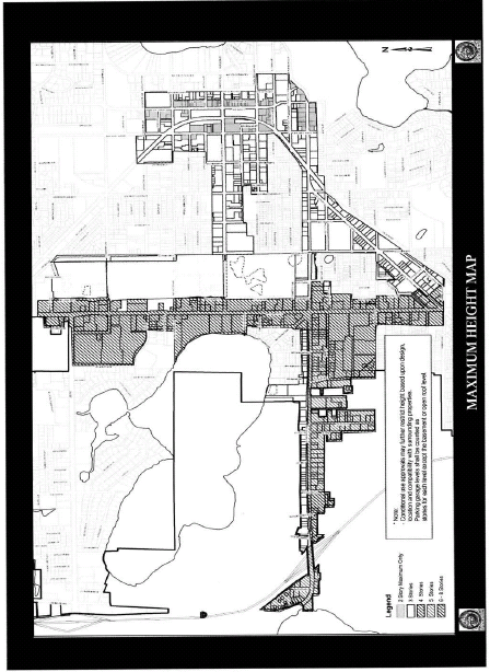
(Ord. No. 2796, § 1, 2-22-10)